Contents
Highlights for Fiscal Year 2013
Geospatial Platform 2.0 Released this Year
FGDC Actions to Prioritize Coordination and Reduce Duplication
Appendix A. FGDC Leadership Profiles
Appendix B. FGDC Structure and Membership
Appendix C. National Geospatial Data Asset Themes
Appendix D. Glossary of Abbreviations and Terms
Message from the FGDC Chair
It is my pleasure to present the Federal Geographic Data
Committee’s (FGDC’s) annual report for 2013. This report provides
management and performance information and describes the significant
actions the FGDC has taken over the past year to facilitate continued,
integrated, and sustainable development and dissemination of geospatial
data and technology. This year in an Executive Order, President Obama
recognizes the importance of data that is open to, and accessible by,
the public. One of Secretary of the Department of the Interior Sally
Jewell’s priorities is to elevate the understanding of our Nation’s
resources to a landscape level. The FGDC’s accomplishments and goals
not only are consistent with these directives but give us a running
start at completing these missions.
During the past year the FGDC has undertaken a major effort to develop
an updated strategic plan for the National Spatial Data Infrastructure
(NSDI). The plan is being developed through extensive outreach and
collaboration with Federal agencies, the National Geospatial Advisory
Committee, leadership in the commercial and academic geospatial
communities, and other external partners. The strategic plan will
describe a shared national vision for the NSDI and will include a clear
set of goals and objectives for the FGDC agencies. I believe the plan
will provide a clear roadmap for the FGDC’s activities over the next
several years. To maximize its utility, the plan will also provide
guidance for Federal agencies and other stewards of geospatial
information.
The FGDC and its partners have made great strides in the continued
development of the Geospatial Platform. The Geospatial Platform is a
"one-stop" shared technology environment that enables the publication
and organization of geospatial data provided by government agencies and
their trusted partners. Version 2.0 of Geoplatform.gov, which was released in July 2013,
includes major new features such as a completely redesigned website,
close integration with Data.gov and other national information sharing
efforts, the establishment of Geoplatform.gov "communities," and a Marketplace
function that supports better coordination of Federal geospatial
investments. In 2013 and 2014, we will continue to release new features
and capabilities on a regular basis.
The FGDC has also taken important steps to implement the management
practices described in the Supplemental Guidance to Office of
Management and Budget (OMB) Circular A–16, "Coordination of Geographic
Information and Related Spatial Data Activities." The FGDC has
developed a draft implementation plan for the Supplemental Guidance
that outlines a process to use portfolio management approaches to more
effectively manage Federal geospatial assets and investments. The
implementation plan will assure consistent recordation and management
of geospatial data, facilitating the use and accessibility of the data
among a spectrum of Federal agencies. In fiscal year 2014, the FGDC
will finalize the plan and continue the implementation of this
important process.
The FGDC has continued to make progress in the area of establishing
standards for various types of geospatial data. The FGDC endorsed five
geospatial standards in calendar year 2013 and continued its
longstanding efforts to increase awareness and implementation of
geospatial metadata standards.
The FGDC made substantial progress on multiple levels in the past
year, despite significant budgetary constraints. The staff of the FGDC
Secretariat and the Senior Agency Officials for Geospatial Information
at the various Federal agencies worked diligently and efficiently to
address the increasing and accelerating needs for integrated geospatial
information. The accomplishments over the past year have been informed
by extensive collaboration and coordination with our network of
partners in other levels of government, the private sector, nonprofit
organizations, and academia through the National Geospatial Advisory
Committee. I appreciate the hard work of the dedicated employees from
multiple organizations across the country who carry out the work of the
FGDC.
Fiscal year 2014 will focus on continued collaboration with Federal
and non-Federal partners to advance national geospatial programs. The
FGDC will finalize and begin implementation of the NSDI Strategic Plan
and the A–16 Implementation Plan and will work with partners to enhance
the Geospatial Platform for the benefit of the agencies and the public
we serve. We look forward to continuing our progress and partnerships
in the coming year.
Sincerely,
Anne Castle
FGDC Chair
Assistant Secretary of the Interior for Water and Science

Anne Castle with some of the original National Geospatial
Advisory
Committee during the September 2013 NGAC meeting. Left to right,
Ivan DeLaotch, Anne Castle, Anne Hale Miglarese, Matt O’Connell,
Jack Dangermond, Jerry Johnston, and Dick Clark.
Highlights for Fiscal Year 2013
Geospatial Line of Business
The Geospatial Line of Business (LoB) successfully transitioned to activities focused on the implementation of the Geospatial Platform as a mechanism for developing and delivering shared services for geospatial information across government agencies. The Geospatial Platform offers access to trusted geospatial data, services, and applications managed in the Federal Geospatial Portfolio to support Federal, State, Tribal, and local governments in meeting their mission objectives, and to provide efficiencies and cost savings through shared infrastructure and enterprise solutions. The Portfolio is defined in the Office of Management and Budget (OMB) Circular A–16 Supplemental Guidance. For more information click here.
OMB Circular A–16 Supplemental Guidance
OMB Circular A–16 Supplemental Guidance provides the foundation for a portfolio management approach to the National Geospatial Data Asset (NGDA) portfolio. This approach is based on management units called Themes and their associated NGDA Datasets. Activities during fiscal year 2013 included: completion of the 16 NGDA Theme definitions and their approval by the FGDC Steering Committee, continued identification of datasets associated with each NGDA Theme, identification of the NGDA Theme lead agencies, NGDA Theme Executive Champions and Theme Leads, development of baseline maturity assessment tools for NGDA Themes and Datasets, registration of many of the NGDA Datasets to the Geospatial Platform, and the creation of a Theme Lead collaboration community on the Geospatial Platform. For more information click here.
GeoCloud Initiative Supports the Geospatial Platform
Two geospatial services with a national scope were placed into operation in the Geospatial Cloud (GeoCloud) in fiscal year 2013: the U.S. Department of Education School District Demographics System (SDDS) and the U.S. Army Corps of Engineers Inland Electronic Navigation Charts (IENC). Both services are now operating in the Amazon cloud infrastructure. The services support the interactive use and standards-based application programming interfaces (APIs) that enable access by other software clients. For more information see click here.
NSDI Strategic Plan
The FGDC organized and led an effort to develop a new strategic plan for the National Spatial Data Infrastructure (NSDI). The plan is being developed through extensive outreach and collaboration with Federal agencies, external partners, and the National Geospatial Advisory Committee. The plan will describe a shared national vision for the NSDI and outline the actions the Federal Government will take to contribute to this vision. The plan will provide a roadmap for the FGDC’s activities over the next several years. For more information click here.
National Geospatial Advisory Committee
During the past year the National Geospatial Advisory Committee (NGAC) analyzed and provided feedback and recommendations to the FGDC on the NSDI Strategic Plan, the Geospatial Platform initiative, the National Hydrography Dataset, and the proposed National 3D Elevation Program and National Address Database. For more information click here.
Standards
The FGDC endorsed five standards in calendar year 2013: (1) ISO 19156:2011, Geographic Information - Observations and Measurements; (2) OGC® WaterML 2.0: Part 1- Time Series Encoding Standard; (3) Geopolitical Entities, Names, and Codes (GENC) Standard Edition 1; (4) Revision of the Classification of Wetlands and Deepwater Habitats of the United States Standard; and (5) Time Space Position Information (TSPI) standard, Version 2.0. For more information click here.
Geospatial Metadata
Working with several Federal agencies, the FGDC Secretariat organized and led an International Organization for Standardization (ISO) Metadata Implementation Webinar that addressed the 2011 FGDC Metadata Summit recommendations to increase awareness about ISO geospatial metadata standards and develop strategies to move agencies forward with implementation. Additionally, the Metadata Working Group released an updated charter in July 2013. For more information click here.
NSDI Training Program
The NSDI Training Program began shifting toward implementation of the standards, polices, technology, and human resources that comprise the NSDI, including ISO metadata, an Open Data Policy, A–16 Supplemental Guidance, the Geospatial Platform, and the NSDI Strategic Plan. For more information click here.
| NOAA’s Senior Agency Official for Geospatial Information Honored | |
| Mr. Joseph Klimavicz, the Department of Commerce Senior Agency
Official for Geospatial Information (SAOGI), was recently recognized
with the fiscal year 2012 Distinguished Presidential Rank Award as an
exceptional leader who has demonstrated his ability to bring people,
processes, and technology together, working across organizational
boundaries, to create efficiencies and increase mission effectiveness
by delivering large-scale complex transformations. Since 2007 Mr.
Klimavicz has been NOAA’s Chief Information Officer (CIO) where he
leads NOAA’s management of information and implementation of
information technology (IT), which includes NOAA’s high-performance
computing and communications infrastructure and NOAA’s Homeland
Security program to ensure NOAA’s emergency response and business
continuity. As a SAOGI he is an active member of the FGDC Executive and
Steering Committees where he provides invaluable leadership and insight
to activities related to OMB Circular A–16 and the implementation of
the National Spatial Data Infrastructure. Mr. Klimavicz led the
development of the initial instance of Geoplatform.gov and its migration to the new
national Geospatial Platform, which included the creation of a NOAA
community within the Platform’s website. |
 |
Geospatial Platform 2.0 Released this Year
![]()
Introduction
The Geospatial Platform (Geoplatform.gov) is a major initiative of the FGDC
and considerable progress has been made on its development throughout
the year. At its core, the Platform features a shared technology
environment that enables the publication and organization of geospatial
data provided by government agencies and their trusted partners. This
effort is a component of the Administration’s Information Technology
(IT) Shared Services initiative and is designed to help agencies more
effectively produce and share their geospatial data, services, and
applications across the government and externally.
More specifically, the Geospatial Platform initiative is designed to
offer a number of features to Federal agencies and their partners,
including:
- a "one-stop-shop" to deliver trusted, nationally consistent data and services;
- authoritative data to support informed decisionmaking;
- problem-solving applications and services that are built once and used many times across multiple Federal agencies and other organizations;
- a shared cloud-computing infrastructure to host data and applications; and
- a national and Federal focal point where governmental, nongovernmental, private, and public data and applications can be visualized together to inform and address national and regional issues.
Our past efforts in this area have led to the development of the Business Plan for the Geospatial Platform, approved by the FGDC Steering Committee in September 2012. This document, along with the companion "Modernization Roadmap for the Geospatial Platform" and "Building the Business Case for the Geospatial Platform—The Value Proposition" have served as the blueprint for our work in transforming the prototype implementation of Geoplatform.gov into a fully operational set of capabilities. As a part of that effort, this year the FGDC released a completely new and greatly improved version of Geoplatform.gov.
Improved Capabilities Supporting Improved Outcomes
Version 2.0 of Geoplatform.gov was released in July 2013
and, in the spirit of continuous improvement, new features and
capabilities are being released on a regular basis. Major new features
in the Version 2.0 release include the following:
A Redesigned Website
The Geoplatform.gov website was completely redesigned for this release. Built using Drupal, an open source Web content management system (www.drupal.org), the content of the new site is arranged based on user needs and the types of services available. The site also now includes a prominent space for featuring stories about the Platform and a number of other capabilities designed to enhance community engagement and collaboration.
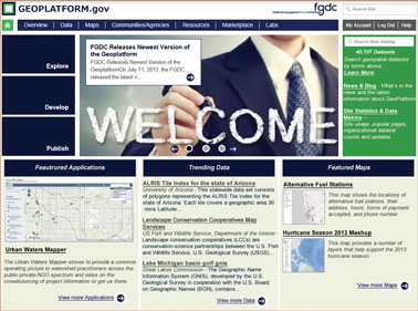
Home page for Geoplatform.gov.
Tight Integration with Data.gov
Since the beginning of the Data.gov program, the national geospatial community and the FGDC members have been leaders in providing the vast majority of metadata records to the governmentwide clearinghouse. From a usability perspective, though, we have been challenged in the past by the fact that geospatial catalog holdings have been maintained and discoverable via separate user interfaces and tools from other portions of the Data.gov catalog holdings. For the Version 2.0 release of Geoplatform.gov, we have worked very closely with the Data.gov team to bring these capabilities together, and we are now using the master Data.gov catalog as a service for the benefit of Geoplatform.gov users.
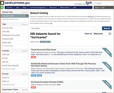
Example of search results from Geoplatform.gov.
Integration with National Information-Sharing Efforts
One of the most exciting developments for the Geospatial
Platform this year has been our interaction and engagement with several
whole-of-government initiatives designed to improve our Nation’s
capabilities for effectively sharing geospatial information. This
includes efforts to integrate the capabilities of the Geospatial
Platform with the Department of Homeland Security’s Sensitive but
Unclassified environment for geospatial data sharing, the "Geospatial
Interoperability Infrastructure," and efforts to collaborate with the
Homeland Infrastructure Foundation-Level Data (HIFLD) Working Group
community to define and implement improved governance, coordination,
and technical capabilities for information sharing. Additionally, the
Geospatial Platform team has been working closely with the Office of
the Program Manager for the Information Sharing Environment (PM-ISE) to
codify the role of the Geospatial Platform as the government’s
geospatial data publication and sharing environment for unclassified
information.
| A Shared Catalog Solution In fiscal year 2013, the FGDC participated in the design and deployment of a shared catalog solution for both Data.gov and the Geospatial Platform—known as Catalog.Data.gov. This solution, based on the open source CKAN (Comprehensive Knowledge Archive Network) distribution originally deployed as the national solution for the United Kingdom ("data.gov.uk), replaces two separate catalogs and allows search access to all governmental data. Its single index includes all spatial and nonspatial metadata from Federal agencies and their non-Federal partners’ catalogs. The catalog user interface allows for the discovery of data based on "search facets"—fields that can be selected by a user to rapidly focus on topics, sources, and locations. Where data are associated with geospatial data or services of a known type, they can be launched in one of two available interactive viewers. A rich application programming interface (API) is available to enable developers to further refine the search and presentation experience. The collaboration has also produced the Communities Web portal module created for Data.gov to be used in the Geospatial Platform environment. This module will be used as a template for OMB Circular A–16, agency, and cross-cutting activities to customize their own community resource environments under the Geoplatform.gov portal. |
Geospatial Platform Marketplace
The Geospatial Platform’s new Marketplace functionality was
designed with three goals in mind: (1) to broker partnerships among
organizations seeking to procure or create data of common interest; (2)
to help agencies avoid duplicative or redundant spending; and (3)
ultimately, to help measure the effectiveness of the Marketplace in
terms of promoting these interactions and the derived cost savings and
avoidance. With the Version 2.0 release of Geoplatform.gov, we
have made progress toward achieving these goals, and users will be able
to quickly and easily search for "planned" data acquisition activities
that are provided by FGDC partners as metadata records to the Data.gov catalog. This
represents only the most basic functionality that the Marketplace will
ultimately feature, and more capabilities will be released in the near
future.
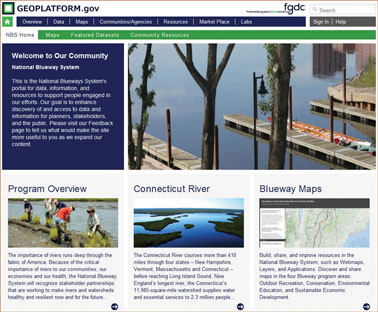
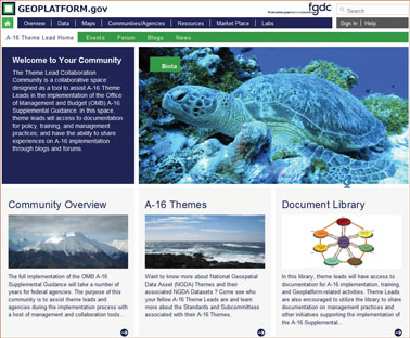
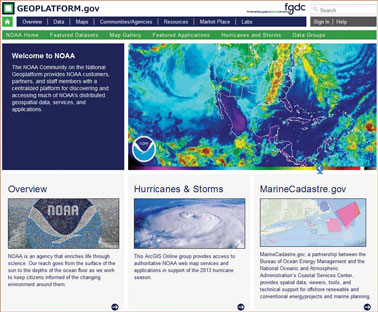
Geoplatform.gov Communities
Perhaps the most prominent new feature of Geoplatform.gov is
the incorporation of "communities"—interactive, topically focused
sections of the website that are managed and used for collaboration by
specific communities of interest. Version 2.0 of Geoplatform.gov
features communities for a national collaborative environmental
management program, for agency program leads who are responsible for
Theme leadership under OMB Circular A–16, and for the benefit of an
individual agency in presenting its data and tools to the public. Many
more communities are under development for Geoplatform.gov, and
this will be one of the most exciting areas of the site to continue to
watch over the coming months.
| Information-Sharing Continuum Efficient and seamless information sharing has been a longstanding challenge within components of the U.S. Government and our mission partners in other organizations. Working with our partners in the Department of Homeland Security (DHS) and the Office of the Program Manager for the Information Sharing Environment (PM-ISE), the FGDC is helping define the role of the Geospatial Platform in the broad geospatial information-sharing continuum. Through our shared efforts to develop an overall "Geospatial Interoperability Reference Architecture" (GIRA), we are working to establish the technology and policy standards framework that must be in place to ensure effective sharing of spatial information from classified networks (the National System for Geospatial Intelligence) to sensitive but unclassified networks (the DHS Geospatial Interoperability Infrastructure) to fully unclassified networks (the Geospatial Platform). This will enable sharing of content via a "no wrong door" access mechanism to authorized users from among all of our partners who have shared mission responsibilities. 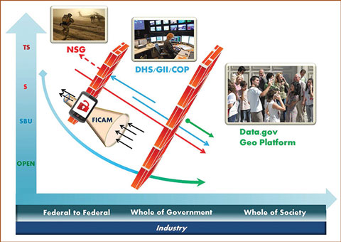 |
High-Priority Work for Next Geoplatform.gov Releases
Heading into fiscal year 2014, we are continuing to advance
Geoplatform.gov in
a number of ways. Because this will be the first full year of funding
support for the Geospatial Platform initiative, the FGDC members and
our partners have much to look forward to as our shared capabilities
advance. Some of the most prominent areas of effort in early fiscal
year 2014 will include:
- Development of Communities for A–16 Themes. Each of the content Themes defined under the Supplemental Guidance to OMB Circular A–16 will be featured as a Theme community on Geoplatform.gov. Identified Theme Leads and Dataset Managers will be able to work collaboratively to feature their nationally significant data assets, as well as their tools and applications that are built using these and other data available on Geoplatform.gov. We will also begin the publication of Theme and Dataset lifecycle metrics on the site to create a series of information dashboards that will help users quickly and easily review key information on progress toward our shared goals. Theme communities will also have collaborative capabilities that will allow Theme participants and their stakeholders to share best practices, tips, and lessons learned from their efforts.
- Geospatial Hosting Services. The Geospatial Platform Managing Partner will be developing shared cloud-computing infrastructure for data and application hosting by the FGDC community. This will include opportunities for cloud hosting of data and map services defined as nationally significant data assets under the Supplemental Guidance. This shared data-hosting environment is potentially the most impactful component of the overall Geospatial Platform implementation, and we are looking forward to helping our partners serve their data, tools, and applications in an efficient, secure, and cost-effective manner.
- Expansion of Self-Service Capabilities for Communities. The Geoplatform.gov communities that were developed and released throughout fiscal year 2013 served as our prototyping efforts for defining a number of self-service content management and authoring capabilities that will be released to community administrators in fiscal year 2014. In the near future, community administrators will have the ability to assign content publication privileges to different members of their communities, invite others to register and access resources that are not available to public users, and much more.
Technological advancements are important to the overall
success of the Geospatial Platform; however, a true measure of success
in this effort will be the volume and quality of nationally significant
data that are made available through Geoplatform.gov. Throughout 2014, the entire FGDC
community will continue working together toward implementation of the
Supplemental Guidance to OMB Circular A–16, and more and more
high-quality content will be available through the infrastructure of
the Geospatial Platform.
| Geospatial Platform Community Types to Foster
Collaboration The Geospatial Platform provides Geoplatform.gov communities with online work space and tools to enable them to address an issue collaboratively. A community coalesces around a common goal, such as understanding and addressing an issue, developing a resource, or providing a service. The Geospatial Platform Version 2.0 is currently supporting three types of content-organized communities representing different community focuses:
Many missions, priorities, events, and activities benefit from collaborative solutions. The Geospatial Platform provides multiple types of communities that support these efforts. |
|
Success Story A
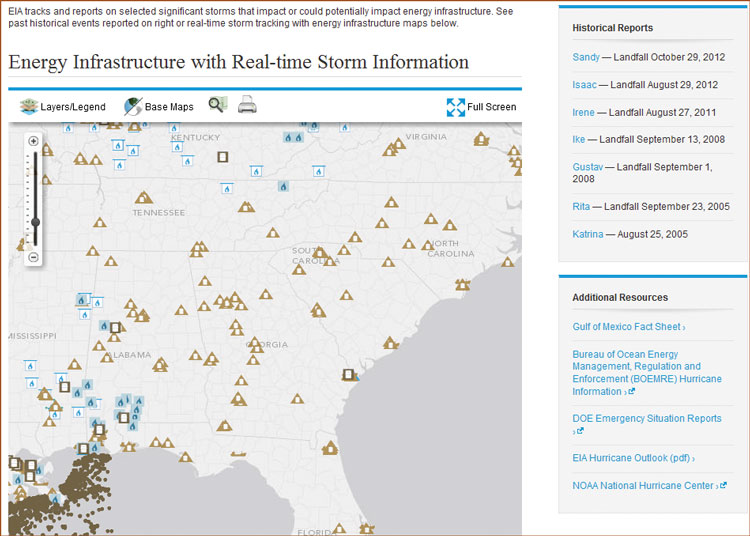
New Web Tool Highlights Hurricane Risk for Energy Infrastructure Challenge: Every year hurricanes and other extreme weather events threaten life and property, including the United States’ energy infrastructure, especially when storm paths traverse offshore production rigs and pipelines, coastal refineries, power plants, and energy import and export sites. No existing tool allowed for the visualization and understanding of potential impacts of a storm on the Nation’s energy network.
Action: The U.S. Energy Information Administration (EIA) developed an interactive energy disruption map, found at www.eia.gov/special/disruptions, which combines real-time storm information from NOAA with more than 20 infrastructure layers from the EIA, the U.S. Bureau of Ocean Energy Management, the U.S. Department of Transportation, and Ventyx. These organizations make their map layers and services in the same industry-standard format.
Result: Whenever a user views EIA’s disruption map, the Web browser integrates the latest storm information directly from NOAA with energy infrastructure data from several sources stored on EIA servers. Upon its release on July 9, 2013, the disruption map was well received by the public and was reported on by Smithsonian Magazine, Federal Computer Week, Information Week, Government Technology, the Houston Business Journal, and others. Even the Wall Street Journal took note of the "nifty new tool" and its significance for oil and gas traders who typically need to track severe weather around the Gulf of Mexico because of the potential for disruption to the region’s oil and gas production and delivery infrastructure. EIA’s disruption map highlights the Department of Energy’s commitment to coordinate their geographic information system (GIS) efforts with their Federal, State, and private partners to reduce GIS costs, improve the quality of services, and increase efficiency to support the interagency emergency response community. This Web mapping service is an example of a prospective application for inclusion in the Geospatial Platform.
|
FGDC Actions to Prioritize Coordination and Reduce Duplication
 |
Background In November 2012, the U.S. Government Accountability Office
(GAO) culminated a year-long review of FGDC activities with the release
of "Report to the Committee on Homeland Security and Governmental
Affairs, U.S. Senate, GEOSPATIAL INFORMATION: OMB and Agencies Need to
Make Coordination a Priority to Reduce Duplication, GAO-13-94." The GAO
was asked to "determine the extent to which the Federal Government has
established and effectively implemented policies and procedures for
coordinating its investments in geospatial data and avoiding
duplication." To address this objective, GAO focused on governmentwide
activities to implement the National Spatial Data Infrastructure (NSDI)
as well as the efforts of the FGDC. The report includes recommendations
to the FGDC and to each of the three Departments that were part of the
GAO review—the Departments of the Interior, Commerce, and
Transportation. |
Recommendations to Departments
The actions directed to the Departments include departmental
policy and planning activities, as well as activities to advance data
themes and further align them with Office of Management and Budget
(OMB) Circular A–16 responsibilities. The departmental actions include:
preparing strategies for advancing geographic information and related
geospatial data activities, policies for making metadata available
through the NSDI clearinghouse, policies for searching the
clearinghouse prior to expending funds on new data activities,
preparing goals and implementation plans for populating the hydrography
and transportation themes, and creating theme standards for the
geodetic control, hydrography, and transportation themes. The report
also recommends that OMB develop a mechanism to annually report on all
geospatial investments, including dollars invested and the nature of
the investment.
A number of the recommendations on departmental policy and theme
activities are common across the Departments, and collaboration is
occurring on common solutions. For example, it is recommended that all
three Departments "prepare, maintain, publish, and implement a strategy
for advancing geographic information and related geospatial data
activities appropriate to its mission." These departmental plans need
to align with the overall NSDI Strategic Plan (see Recommendation 3 below). As such, these
agencies make up part of the NSDI Strategic Planning core team that is
providing weekly review and guidance for the NSDI Strategic Plan,
helping to ensure this alignment.
Recommendations to the FGDC Steering Committee
Three recommendations are directed to the FGDC Steering
Committee for action. In a January 15, 2013, memorandum, FGDC Chair
Anne Castle, Department of the Interior (DOI) Assistant Secretary for
Water and Science, directed the Steering Committee to take the actions
required to address the recommendations and, in addition, to the
implementation of the Geospatial Platform (which is closely tied to a
number of the actions). These actions were the primary focus of the
Steering Committee’s activities during the year. "Responsible
officials" from the FGDC Executive Committee have been identified for
each action and target completion dates have been set. A summary of
each recommendation and the supporting actions is described
below.
Recommendation 1: "Establish a time frame for completing a plan to
facilitate the implementation of OMB’s portfolio management guidance,
and implement the plan within the established time frame." Responsible
Officials: Adrian Gardner, NASA, and Ivan DeLoatch, FGDC Office of the
Secretariat, DOI/USGS. Target Date: Fiscal Year 2014, First
Quarter.
This recommendation refers to OMB’s A–16 Supplemental Guidance, which
includes a governmentwide portfolio management approach to geospatial
data asset management. In June 2013, a memorandum from the FGDC Chair
was sent through the President’s Management Council to the FGDC member
agencies to identify Theme Leads and Executive Theme Champions who will
be responsible for implementing the plan and executing the roles and
responsibilities outlined in the Supplemental Guidance. The
implementation plan provides the steps to inventory, assess, document,
and report on the Federal data portfolio Themes and Datasets and
utilizes the Geospatial Platform to form communities of interest for
the Themes and provide a reporting dashboard.
Recommendation 2: "Develop and implement guidance for identifying
planned geospatial investments using the Geospatial Platform, and
establish a time frame for doing so." Responsible Official: Jerry
Johnston, Geospatial Information Officer, DOI. Target Date: Fiscal Year
2013, Fourth Quarter.
The Geospatial "Marketplace" is being implemented on the Geospatial
Platform as an online service that enables agencies to post metadata
records for "planned" data investments. Utilizing the shared data
catalog between the Geospatial Platform and Data.gov, agencies can register a record that will
be presented in the Marketplace community to enable collaboration by
Federal and other agencies for the joint investment of data, to
minimize redundant data collection, and to leverage saving of
scale.
Recommendation 3: "Create and update a
strategic plan to improve coordination and reduce duplication, and
create and implement the plan within the established time frame …
outcome oriented goals and objectives that address all aspects of the
NSDI." Responsible Officials: Daniel Cotter, DHS, and Ivan DeLoatch,
FGDC Office of the Secretariat, DOI/USGS. Target Date: Fiscal Year
2014, First Quarter.
The NSDI Strategic Plan is a national plan, and the FGDC has received
valuable insight and recommendations for the plan from the National
Geospatial Advisory Committee (NGAC) and through forum meetings with
partnering organizations. The second version of the plan was made
available for public comment in August 2013, and the comments were a
focus for the Steering Committee, Executive Committee, and NGAC
meetings in September. The plan takes the input from the broader
community on the Federal agency roles, responsibilities, and priorities
and combines it with the Federal agency input to set objectives, goals,
and actions for the Federal agencies for the next 3 years. For more
information on the development of a new NSDI Strategic Plan click here.
Summary
The FGDC member agencies are collaborating closely on these
actions and actively engaging the broader community and partnering
organizations. The actions are a positive step forward in implementing
the NSDI, setting Federal geospatial goals for the next 3 years, and
implementing tools to help increase efficiency and reduce redundancy.
The FGDC would like to thank the NGAC members and members of the
broader geospatial community who continue to provide valuable insight,
recommendations, and advice relating to these key actions; the FGDC
looks forward to continuing the dialog in support of advancing the NSDI
as a key national asset.
Fiscal Year 2013 in Review
Geospatial Line of Business Focuses on the Geospatial
Platform
The Geospatial Line of Business (LoB) successfully
transitioned to activities focused on the implementation of the
Geospatial Platform as a mechanism for developing and delivering shared
services for geospatial information across government agencies. The
Geospatial Platform activity demonstrates advancement in our
collaborative effort to support geospatial activities across Federal
agencies and helps to improve the efficiency of government by making
geospatial data more accessible, reliable, and less expensive to
acquire through enhanced data sharing and more effective management of
resources. Access to the Geospatial Platform is at Geoplatform.gov. The
Geospatial Platform offers access to trusted geospatial data, services,
and applications managed in the Federal Geospatial Portfolio to support
Federal, State, Tribal, and local governments in meeting their mission
objectives. The Geospatial Platform also provides efficiencies and cost
savings through shared infrastructure and enterprise solutions. The
Portfolio is defined in the Office of Management and Budget (OMB)
Circular A–16 Supplemental Guidance.
Geospatial Platform Capabilities Demonstrated
Federal and State agencies joined forces to test the
inaugural Geospatial Platform capabilities for use as part of a
Hurricane Response community. Led by the Federal Geographic Data
Committee Office of the Secretariat, participants included: the
Department of the Interior, U.S. Geological Survey, EROS, Department of
Commerce/National Oceanic and Atmospheric Administration, Department of
Homeland Security, Federal Emergency Management Agency, and the Texas
Natural Resources Information System, with technical support from Esri.
The group developed the "Geospatial Platform: Concepts, Roles, and
Responsibilities for Communities and Groups, February 22, 2013" white
paper and created a video providing a use-case example showing how
collaborative map products can be created and how they would apply in
relation to a hurricane event. All these efforts were accomplished
utilizing virtual meetings and centrally registered, remotely managed
geospatial data services.
For recent developments in the Geospatial Platform see the feature article.
| SmartBUY Saving Taxpayer Dollars The FGDC’s Geospatial Line of Business (LoB) initiative has been committed to helping government agencies discover and efficiently procure the best available geospatial software solutions for their mission needs. A component of the Geospatial LoB was established and it provided information necessary to help organizations determine a best value geospatial software solution, or transition an existing agreement or license to more advantageous terms under the Geospatial Software SmartBUY Blanket Purchase Agreement (BPA). Cost savings from the September 30, 2009, award to summer 2013 are shown in the chart and support the value and success of the Geospatial LoB SmartBUY.
|
OMB Circular A–16 Supplemental Guidance Implementation Moves
Forward
The NSDI vision is that the NSDI leverages investments in
people, technology, data, and procedures to create and provide the
geospatial knowledge required to understand, protect, and promote our
national and global interests. This enhances the understanding of our
physical and cultural world by gathering spatial data from multiple
sources (Federal, State, Tribal, and local governments, academia, and
the private sector) and sharing access to the data so that the data are
readily available and easily integrated. The intent is to improve
support of mission-critical business requirements of the Federal
Government and its stakeholders. The Supplemental Guidance to OMB
Circular A–16 plays a key role in meeting this vision. It further
defines and clarifies elements outlined in OMB Circular A–16 to
facilitate the adoption and implementation of a coordinated and
effective Federal geospatial asset management capability. The
Supplemental Guidance also provides the foundation for a portfolio
management approach to National Geospatial Data Asset (NGDA) Themes and
their associated NGDA Datasets. Each Theme contains multiple associated
geospatial datasets (with attribute records and coordinates) that are
documented, verifiable, and officially designated to meet recognized
standards.
Portfolio management, described in the Supplemental
Guidance, is the coordination and management of Federal geospatial data
assets and investments to most efficiently support national priorities
and government missions. Portfolio management applies consistent
management approaches that help increase the quality of data through
use of best practices and documentation in a manner that reduces
duplication and cost, provides greater accessibility, and supports
shared services across the Federal Government. Through portfolio
management, NGDA Datasets are organized into management units called
Themes, which are managed by Theme Leads who are to provide
cross-agency leadership and coordination for the Theme. The Datasets
are managed by Dataset Managers who are to provide coordination and
standards for the Datasets at a national level. Datasets within Themes
will be made available through the Geospatial Platform (Geoplatform.gov).
During fiscal year 2013, the FGDC Steering Committee
approved a reduction of Themes from 17 to 16 and refined definitions
for several of the NGDA Themes, which update the themes identified in
OMB Circular A–16, Appendix E. The Theme descriptions, scope, and
initial list of associated Datasets will continue to evolve as business
and stakeholder needs warrant.
Lead agencies for all NGDA Themes with the exception of the
Terrestrial portion of the Utilities Theme were also approved by the
FGDC Steering Committee this year. Theme Leads were identified for all
but two NGDA Themes, and Executive Champions were approved for 9 of the
16 NGDA Themes. Dataset managers have been identified for all NGDA
Datasets. The NGDA Themes, lead agencies, descriptions, and scope are
outlined in Appendix C. A link to the NGDA Datasets list is available
at www.fgdc.gov/initiatives/portfolio-management.
The FGDC is developing an online Geospatial Data Lifecycle
Evaluation and an NGDA Theme and Dataset Administrative Assessment to
assist Theme Leads and Dataset Managers in assessing/evaluating the
current maturity of NGDA Themes and Datasets. The results of the
evaluations and baseline assessment are intended to be the basis of
Theme Leads and Dataset Managers to report on the maturity of their
respective NGDA Themes and Datasets within the NGDA Portfolio as
required by the OMB A–16 Supplemental Guidance. As a start, the Theme
Leads for Elevation and Governmental Units and Administrative and
Statistical Boundaries presented at the June and September 2013,
respectively, FGDC Steering Committee meetings.
In May 2013, the Federal Government released a new unified
data catalog that supports both Data.gov and the Geospatial Platform. In an effort
to maximize discovery of Datasets in the NGDA Portfolio, the FGDC
performed a metadata evaluation and registration assessment of NGDA
Datasets on the joint Geospatial Platform/Data.gov catalog. The results
of this evaluation were presented to Theme Leads who are currently
coordinating with Dataset Managers in their respective Themes to
complete action items for data registration and metadata compliance for
NGDA Datasets.
As implementation of the A–16 Supplemental Guidance across Federal agencies moves forward, a key factor in the success of implementation will be the ability for Theme Leads, Dataset Managers and stewards, and other stakeholders to coordinate and work together on implementation. To help encourage and strengthen this across agencies and within communities, the FGDC will begin establishing NGDA Theme communities on the Geospatial Platform. These communities will serve as space for cooperation as well as provide access to Theme-specific data and resources. It is the vision of the FGDC to have a community on the Geospatial Platform for each of the 16 NGDA Themes and to begin to establish these communities in fiscal year 2014. For additional information about NGDA Theme communities and other communities on the Geospatial Platform click here
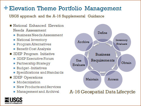
| Elevation Theme Portfolio Management The terrestrial elevation component of the OMB A–16 Elevation Theme is led by the USGS and includes the 3D Elevation Program (3DEP) and other datasets. The primary goal of 3DEP is to systematically collect over an 8-year period (1) high-quality light detection and ranging (lidar) data over the conterminous United States, Hawaii, and the U.S. territories; and (2) interferometric synthetic aperture radar (ifsar) data over Alaska, where cloud cover and other conditions limit lidar acquisition. To fulfill its responsibilities for A–16 Elevation Theme Portfolio Management, the USGS has made significant progress in addressing all aspects of the data lifecycle management guidelines in developing 3DEP and will be assessing the other NGDA Elevation Theme datasets as part of the process.
Starting in fiscal year 2013 the FGDC Steering Committee began to receive reports from the A–16 Theme Leads on their Theme’s status, development, and management plans as part of the implementation of the A–16 guidance. The co-leads from the USGS and NOAA for the Elevation Theme were the first to report on the Theme status to the FGDC Steering Committee at the June 2013 meeting. Highlights from the report include:
|
In the response to a recommendation made by the GAO, the
FGDC is currently developing an A–16 Implementation Plan outlining
steps and an associated time frame for implementing the requirements of
OMB Circular A–16 Supplemental Guidance across Federal agencies. It
will include implementation goals and performance measures that will be
reportable to OMB on the progress of implementation. This plan will
also institute portfolio management processes that will include
developing meaningful and consistent performance metrics for NGDA
Themes and Datasets.
GeoCloud Initiative Supports the Geospatial Platform
In fiscal year 2013, the Geospatial Cloud (GeoCloud)
initiative sponsored the operational deployment of key public-facing
geospatial Web services and engaged several new projects as part of the
Shared Services strategy in support of the Geospatial Platform.
GeoCloud offers agencies an ”incubator” or testbed environment where
cloud hosting costs and core software platforms are provided by the
FGDC for up to one year. Once the projects are operational they may be
(1) transferred back to an agency for payment and operations in the
cloud, (2) converted to a reimbursable status hosted in the cloud by
the FGDC/Platform but funded by agencies through interagency agreement,
or (3) retired from the cloud where such services are not cost
effective. Project results including computational performance,
costing, and comparison with non-cloud hosting are posted on the FGDC
and Geospatial Platform websites to enable future projects to learn
from their experiences and plan for the cloud environment.
Two national services were made operational in GeoCloud this fiscal
year. Both provide user interfaces and standards-based APIs that can be
used to view or access the data in other applications. The School
District Demographics System (SDDS) is an interactive map service and
set of standard Web services operated by the National Center for
Education Statistics (NCES) of the U.S. Department of Education (see
text box below). The second national service is the Army Corps of
Engineers Inland Electronic Navigation Charts (IENC) that are now
published as Web services and as a download user interface in GeoCloud.
The IENC service is a nautical charting service that focuses on inland
waterways and provides raster maps that are downloaded and used by GPS
navigation devices in watercraft.
| Using the Cloud to Access School District
Demographics The GeoCloud initiative provided the U.S. Department of Education an opportunity to explore the Amazon Web Services hosting platform for its geospatial applications. The Department of Education’s National Center for Education Statistics (NCES) gained experience with the cloud-based Windows 2008R2 Server and Esri ArcGIS for the Server 10.1 platform. This resulted in a successful migration of its on-premises ArcGIS platform for the School District Demographics System (SDDS). Success for NCES equates to high availability, increased efficiency, and increased innovation with a platform that supports rapid deployment of its geospatial solutions for accessing school district demographic and related geographic data. The information system supporting the SDDS Map Viewer (nces.ed.gov/surveys/sdds) is the main NCES system migrated. This is a publicly available application (also with a mobile version) that allows access from NCES to information about demographics, social characteristics, and the economics of children and school districts. It is the only national system in the United States to visually link the exact geographic location of schools to their demographic and economic information. Since deployment in the GeoCloud Program, NCES has added two new geospatial solutions to its architecture. NCES, with support from the U.S Census Bureau, has started collecting school boundaries for over 13,000 U.S. school districts and is using the cloud servers to support this effort. As with the school district files, NCES disseminates data from sources such as the Census American Community Survey (ACS) mapped against school boundaries and allows relationships between schools in the same district or across the Nation to be examined. The Demographic Profile Viewer (nces.ed.gov/surveys/sdds/ed/profiles/) provides a unique way to better understand patterns in our school systems and visualize key demographic data within school districts and school boundaries for the entire Nation for approximately 600 economic and social characteristics from the ACS profile data and 2010 Decennial Census. 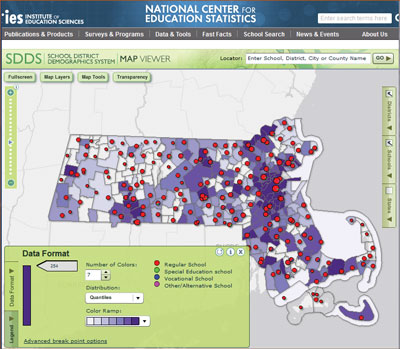 Example from SDDS map viewer. |
Developing a Federal Strategic Plan for the NSDI
The FGDC initiated the development of a new strategic plan
for the NSDI in 2013. The new plan is being developed through extensive
consultation with partners and stakeholders across the geospatial
community. This plan will describe a shared national vision of the NSDI
and include a set of goals and objectives for the Federal Government’s
role in achieving this vision. The goals and objectives in the plan
will define areas of critical importance to the continued development
of the NSDI and provide a framework for the Federal geospatial
community’s responsibilities over the next 3 years. The plan will also
describe the steps the FGDC community will take to implement the goals,
objectives, and actions, including development of project plans and
performance measures in collaboration with partners and
stakeholders.
One of the FGDC’s responsibilities under OMB Circular A–16 is to
"prepare and maintain a strategic plan for the development and
implementation of the NSDI." Executive Order 12906 describes the NSDI
as "the technology, policies, standards, and human resources necessary
to acquire, process, store, distribute, and improve utilization of
geospatial data." A new NSDI plan is important and timely for several
reasons. First, while the FGDC has engaged in a series of strategic
initiatives over the past several years (including the Geospatial Line
of Business and Geospatial Platform initiatives), the current NSDI
Strategic Plan has not been revised for a number of years. Second,
geospatial technologies, industries, and applications have seen
tremendous growth and change over the past several years, and our
strategies need to be modernized to align with and leverage these
changes. In addition, a recent report by the Government Accountability
Office (GAO), "Report to the Committee on Homeland Security and
Governmental Affairs, U.S. Senate, GEOSPATIAL INFORMATION: OMB and
Agencies Need to Make Coordination a Priority to Reduce Duplication,
GAO-13-94," reaffirmed the importance of improving coordination and
reducing potential duplication and recommended the development of an
updated NSDI strategy.
As the plan has been developed, the FGDC has provided multiple
opportunities for participation and input. These opportunities have
included forums for leaders of key geospatial organizations, workshops
for Federal leaders, sessions at geospatial professional conferences,
and public meetings of the FGDC Coordination Group, the FGDC Steering
Committee, and the National Geospatial Advisory Committee (NGAC). The
goal has been to engage leaders of key geospatial organizations in the
early stages of the planning process, gather initial input, and seek
continuing involvement.
 NSDI Leaders Forum, March 2013. 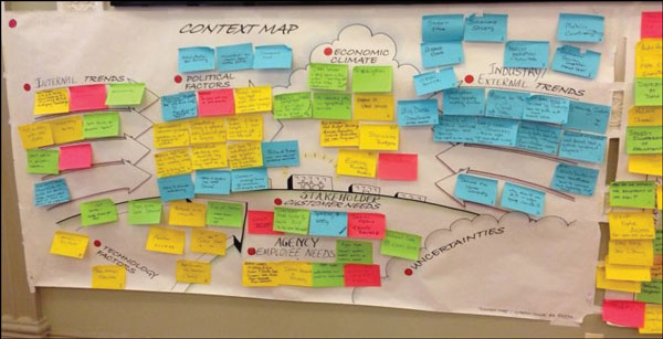 Developing the NSDI Strategic Plan. |
The NGAC, in particular, has provided extensive and
thoughtful input into the plan. The NGAC established a subcommittee and
work groups to provide input on a shared vision for the NSDI, the roles
and responsibilities of the Federal Government, and key external
factors impacting the geospatial community. The NGAC also provided
extensive comments on the draft versions of the plan. The input and
suggestions received from our partners, both within and outside of the
Federal Government, have been instrumental in shaping the new
plan.
The updating of the NSDI Strategic Plan is also consistent with the
Department of the Interior’s priorities on the use of geospatial
technology to deliver data and information to other government entities
and the general public in an understandable and comprehensive manner.
The NSDI framework is intended to govern the way Federal agencies share
and maintain geospatial data and to reduce duplication of effort. For
more information about the NSDI Strategic Plan visit www.fgdc.gov/nsdi-plan.
Promoting Communications via the National Geospatial
Advisory Committee
The National Geospatial Advisory Committee (NGAC) is a
Federal advisory committee sponsored by the Department of the Interior
to provide external advice and recommendations to the member agencies
of the FGDC. The NGAC includes a balanced membership of 29 committee
members representing a variety of organizations involved in geospatial
issues, including all levels of government, the private sector,
nonprofit organizations, and academia. The NGAC meets three to four
times per year and has established subcommittees that conduct research
and develop draft products between committee meetings. Over the past
year, the NGAC has analyzed and provided recommendations on a number of
key geospatial policy issues. Highlights of the NGAC’s 2013 activities
include the following:
- Developed recommendations and provided feedback on several important topics, including the Geospatial Platform initiative, the National Hydrography Dataset, and the proposed National 3D Elevation Program and National Address Database.
- Provided extensive input and comment in the development of the draft NSDI Strategic Plan.
- Adopted a National Geospatial Policy paper outlining the role of geospatial information technology in supporting cost-effective government and stimulating economic growth through job creation. The paper described a set of recommendations for development of a National Geospatial Strategy and the effective utilization of geospatial technology. The recommendations were based on the work and the recommendations of the NGAC since its inception in 2008.
- Adopted a set of papers summarizing the activities and feedback provided by NGAC subcommittees that studied the proposed National Address Database, the proposed National 3D Elevation Program, the National Hydrography Dataset, and OMB Circular A–16 topics.
- Approved a resolution commending the U.S. Department of Transportation’s work on the Transportation for the Nation and MAP-21 (Moving Ahead for Progress in the 21st Century) initiatives to partner with other levels of government to create a single road and highway map for the Nation. The NGAC recommended that these efforts include the collection and integration of street address data with the Highway Performance Monitoring System linear referencing framework.
- Developed papers identifying key questions regarding future issues facing the geospatial community. The topics included geolocation privacy, the National Address Database, and the National 3D Elevation Program.
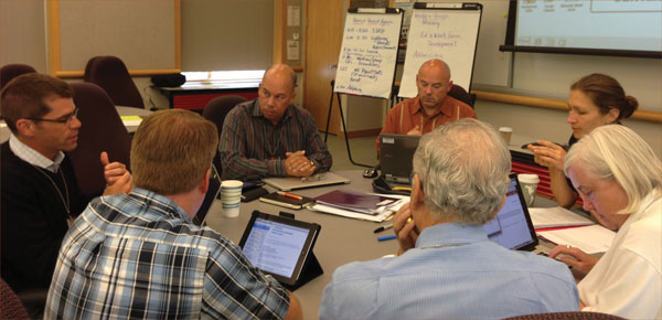
Breakout discussion group during June 2013 NGAC meeting.
Standards Progressing Forward
In calendar year 2013, the FGDC endorsed five
standards:
- ISO® 19156:2011, Geographic information - Observations and Measurements
- OGC® WaterML 2.0: Part 1- Time Series Encoding Standard
- Geopolitical Entities, Names, and Codes (GENC) Standard Edition 1
- Revision of the Classification of Wetlands and Deepwater Habitats of the United States Standard
- Time Space Position Information (TSPI) standard, Version 2.0
International Organization for Standardization (ISO)
19156:2011, Geographic information - Observations and Measurements
defines a conceptual schema for observations and for features involved
in sampling when making observations. It provides models for the
exchange of information describing observation acts and their results,
both within and between different scientific and technical
communities.
OGC® WaterML 2.0: Part 1- Time Series Encoding Standard is
an OGC® Encoding Standard for the representation of
hydrological observations data with a specific focus on time series
structures. WaterML 2.0 is implemented as an application schema of the
Geography Markup Language Version 3.2.1, making use of the
OGC® Observations and Measurements standards. It is designed
as an extensible schema to allow encoding of data to be used in a
variety of exchange scenarios.
The Geopolitical Entities, Names, and Codes (GENC) Standard Edition 1
standard specifies a profile of the ISO 3166 country codes standard and
codes for the representation of names of countries and their
subdivisions. This profile addresses unique U.S. Government
requirements for restrictions in recognition of the national
sovereignty of a country; identification and recognition of
geopolitical entities not included in ISO 3166; and use of names of
countries and country subdivisions that have been approved by the U.S.
Board on Geographic Names (BGN).
The FGDC Wetlands Classification Standard (WCS) provides minimum
requirements and guidelines for classification of wetlands and
deepwater habitats that are consistent with the FGDC Wetlands Mapping
Standard, FGDC-STD-015-2009. The WCS is intended for all Federal or
federally funded wetlands inventory mapping, including activities
conducted by States, federally recognized Tribal entities,
nongovernmental organizations, universities, and others. The revised
WCS has been formatted to be consistent with more recently endorsed
FGDC standards. Some portions were rewritten because the scientific
foundation upon which the original classification was developed has
advanced.
The Time Space Position Information (TSPI) standard Version 2.0
provides a single means of encoding spatiotemporal information for
storage, manipulation, interchange, and exploitation. It specifies a
core XML schema for spatial, temporal, and accompanying quality
assessment characteristics of the real world and a registry-based
extension mechanism enabling the development and reuse of additional
spatiotemporal XML schema components.
In addition, the draft National Shoreline Data Content Standard was
released for public review in 2013. The public review period closed
July 31, 2013.
FGDC/USGS OGC Sponsored Standards
Open Web Services-9 (OWS-9) Interoperability
Testbed
USGS sponsorship of the OWS-9 testbed involved (1) expanding semantic
mediation to include conflation; (2) additional sources of data,
including more complex data and unstructured data; (3) keeping track of
provenance of the data; (4) single query and access capability across
multiple Federal geographic names databases; and (5) further
investigation into encoding mappings.
Global Earth Observing System of Systems (GEOSS) Architecture
Implementation Pilot (AIP)
FGDC sponsored the GEOSS AIP-5 pilot with priority actions that
included GEOSS research and prototyping, GEOSS interoperability
analysis and support, encouraging mature systems to interoperate with
GEOSS Common Infrastructure, and ensuring access to GEOSS Data
Collection of Open Resources for Everyone (Data-CORE).
Hydrology Interoperability Experiment
This interoperability experiment advanced the application of several
OGC standards (WaterML, WFS, WMS, CSW, GML, and O&M) to the needs
of hydrologic information systems. This included addressing several
approaches for water-quality data and forecasting. The experiment
engaged a broader community that is developing an international
information model by harmonizing with and extending existing
initiatives, such as Ground Water Markup Language (GWML), the European
INSPIRE Groundwater Model, and others.
Metadata Program: Putting ISO Metadata into Practice
On April 16 and 17, 2013, working with the National Oceanic
and Atmospheric Administration, U.S. Census Bureau, U.S. Environmental
Protection Agency, and U.S. Geological Survey, the FGDC Secretariat
organized and led an International Organization for Standardization
(ISO) Metadata Implementation Webinar. The webinar was the result of
recommendations that came out of the FGDC-sponsored Metadata Summit in
October 2011. During presentations and discussions held during the two
half-day webinar sessions, 46 participants representing 14 agencies
sought to (1) develop a common language and understanding of ISO
geospatial metadata standards and implementation issues, (2) focus on
actions (roadmaps) required to transition an agency to ISO metadata,
(3) identify available ISO metadata resources, and (4) establish a
community of practice with regular communication and interaction.
An outcome of the webinar was the recommendation to continue enhancing
interagency cooperation through establishment of a regularly hosted ISO
information series, continue development of ISO metadata implementation
training materials, and the creation of an ISO implementation pilot
community. All presentations and materials are available through the
FGDC website (www.fgdc.gov/metadata/events/ISO_Implementation_Webinar).
The ability to create, edit, and publish ISO geospatial metadata
records continues to be an important implementation issue for many
organizations. To facilitate the information available about a variety
of tools, the FGDC, with input from the Metadata Working Group, is
updating the ISO Metadata Editor Review. The review focuses on editors
that support ISO 19115 and is designed based on Metadata Working Group
member input as to key editor selection criteria including: metadata
standards supported, user interface, operating platform, proprietary
nature, Extensible Markup Language (XML) capabilities, validation, and
import/export operations. The review also provides editor developers
with text options in order to more fully describe support features,
edit operations, customization, metadata management, and publication
capabilities.
To support communication about activities, available resources, and
training, the FGDC Metadata Program website is undergoing an update to
reflect transition to the ISO metadata standards and to help the
community locate and use resources in their implementation process.
Several key pages have been updated and enhanced this year and more
will continue to be added.
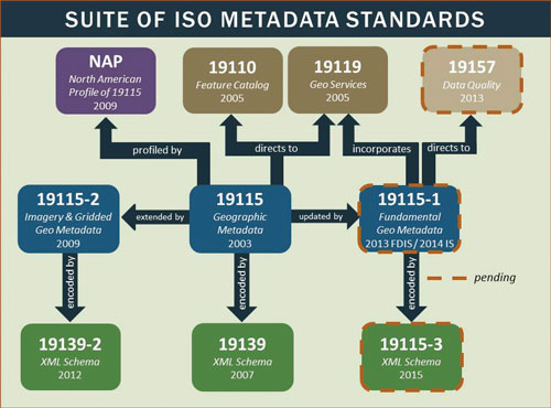
Relation and status of ISO metadata standards.
| Benefits Seen by Census Bureau’s ISO Metadata
Implementation As members of the Federal Metadata Coordinator ISO Metadata Implementation planning team, NOAA, USGS, EPA, and the Census Bureau cooperatively developed a Use Case framework to document and compare their individual agency experience with ISO Metadata implementation. Given that agency expertise and implementation stage varied, the use cases were highly effective in illuminating key implementation factors, including agency mission and structure. The use case outcomes were incorporated into an ISO Metadata Implementation Model Workflow that can be utilized by other agencies and organizations to plan and initiate ISO metadata implementation. The Census Bureau Use Case highlighted several key activities. The staff participated in several training opportunities, including the NOAA training highlighted in the 2012 Annual Report. While policies are under development within the Department of Commerce, the Census Bureau has focused its efforts on implementing the ISO standard format 19115-2 for only new metadata being created. The Bureau has noted benefits including reducing the size of metadata files by incorporating reusable components for contact information and keywords, as well as a tenfold reduction in file size (from over one thousand lines to less than one hundred lines) by using reusable components for contact info and entity attributes in the 19110 file. While full implementation of reusable components is targeted for 2014 products, ISO metadata has been created for TIGER Web map services and for the 2013 cartographic data products and TIGER/Line shapefiles. All of the records will be published to the master catalog used by Data.gov and Geoplatform.gov. |
To support the Geospatial Platform and Data.gov implementation, the metadata community contributed to the development of a best practices document for geospatial metadata creation and publishing (www.geoplatform.gov/sites/default/files/document_library/MetadataPractices07-2013_Linked_0.pdf). The document also includes examples of quality metadata records in both the Content Standard for Digital Geospatial Metadata (CSDGM) and the ISO format. Metadata support was also provided to identify and update information about metadata publishers that had previously contributed to Geodata.gov. Given the importance of metadata to effective data discovery, a spreadsheet was developed that outlines the mandatory and equivalent elements between CSDGM and ISO 19115 and to further support CKAN (Comprehensive Knowledge Archive Network) catalog implementation.
Cooperative Agreements Program Advances the NSDI
Since 1994 the FGDC has sponsored the Cooperative Agreements
Program (CAP) to encourage and enable building the NSDI at all levels
of the geospatial data community. The community not only benefited
financially but more importantly validated an organization’s geospatial
initiatives, which opened new opportunities. The CAP continued to (1)
create collaborations within all sectors of government, (2) help
develop an understanding of geospatial information in organizations new
to the NSDI, (3) provide seed money to enable geospatial organizations
to participate in the national effort to implement the NSDI, (4)
promote the importance of geospatial data standards, (5) promote the
development of standardized metadata by countless organizations, and
(6) greatly expand implementation of geospatial services on the
Internet. For more information see www.fgdc.gov/grants.
This year, 19 CAP projects were concluded. As in past years, training
and outreach continued to be valued outcomes of the program. Over 240
individuals received metadata training through a number of workshops
that were offered in Arizona, Florida, and Iowa. Many Native American
Tribe representatives attended the Arizona workshops. Use of the ISO
geospatial metadata standards was promoted by the Northwest Straits
Commission, and the FGDC United States Thoroughfare, Landmark, and
Postal Address Data Standard was enhanced through the development of
two prototype applications (github.com/candrsn/FGDCAddressTool).
Furthermore, the wetlands science community developed technical
recommendations to address key technical challenges referenced within
the FGDC Wetland Mapping Standard and in its implementation plan. In an
effort to continue the expansion of the NSDI Clearinghouse, Maryland
conducted a successful campaign to populate the National States
Geographic Information Council’s GIS Inventory System (also known as
Ramona, and accessible at gisinventory.net). State agencies from
Massachusetts, North Carolina, and Oregon addressed issues of
integrating and sharing geospatial data to expand the use of best
practices within their States.
In 2013, six Fifty States Initiative projects were completed in
Louisiana, Minnesota, Nebraska, New Jersey, Utah, and Wisconsin that
resulted in strategic or business plans for advancing geospatial
planning activities in these States. As the Louisiana Geographic
Information Center was completing its business plan for statewide
address management, it simultaneously championed the importance of the
FGDC United States Thoroughfare, Landmark, and Postal Address Data
Standard. Minnesota produced a detailed business plan for acquiring,
integrating, managing, and providing access to accurate, current, and
consistent parcel data for the entire State—a system that is based on
maintained and authoritative county sources. Nebraska developed an
enterprise-level strategic plan to guide the development of the State’s
spatial data infrastructure. New Jersey created a strategic business
plan that makes the business case for improvements to its "core four"
datasets, for new investments in the modernization of the New Jersey
Geographic Information Network, and for evolution of governance in the
State. Utah’s Automated Geographic Reference Center launched three
initiatives to support its strategic objectives for the State’s spatial
data infrastructure. Finally, Wisconsin completed a business plan that
summarizes the current state of aerial imagery projects in the State,
proposes a number of unique models that could be used to implement an
imagery program, and identifies the broad steps needed to build the
program.
Other significant CAP projects that were successfully completed
included Return on Investment (ROI) studies by Maine, New York, and
Oregon. Maine conducted a cost-benefit analysis of a statewide
orthoimagery program, projecting that the return on investment would
range from 421 percent to 1,264 percent. New York also studied its
orthoimagery program and concluded that without the statewide program,
many public and private users would be challenged in carrying out their
essential functions, and if they were indeed able to carry out those
functions, their costs for doing so would be much higher and the
quality of their services or products would be lower. The ROI study in
Multnomah County, Oregon, focused on two GIS platforms used for
emergency response. They reported that in the past year, the
benefit-cost ratio for one platform was 6.73:1 and was 3.48:1 for the
other, showing a significant advantage for the use of the emergency
response platforms.
Statewide workshop for the Nebraska strategic plan.
International Activities
The FGDC Office of the Secretariat continues to support
international efforts through the intergovernmental Group on Earth
Observations (GEO) and the Global Spatial Data Infrastructure (GSDI)
Association. These activities are underpinned by the adoption of best
practices and standards to promote interoperability worldwide and
thereby facilitate access to geospatial data and services.
In 2005, the U.S. Group on Earth Observations (USGEO) was established
as a work group under the White House Office of Science and Technology
Policy’s Committee Environment and Natural Resources to be the
principal coordination mechanism in the Federal Government for Earth
observations to achieve a national Integrated Earth Observation System
(IEOS). The United States, through USGEO, supports the cooperative,
international efforts to build the Global Earth Observation System of
Systems (GEOSS) in partnership with 88 other governments and the
European Commission. The USGEO had representatives from sixteen U.S.
Federal agencies and the Executive Office of the President and was
co-chaired by representatives from the White House Office of Science
and Technology Policy (OSTP), the National Oceanic and Atmospheric
Administration (NOAA), and the National Aeronautics and Space
Administration (NASA).
USGEO formulated U.S. positions and inputs to the international GEOSS,
taking into account the requirements of the widest range of
decisionmakers, researchers, service providers, the public, and other
stakeholders. Significant progress has been made in areas such as data
sharing and data delivery and integration, as well as building capacity
in developing nations so that they may realize greater benefits from
Earth observations. Additionally, significant strides have been made to
achieve benefits from greater collaboration and integration of Earth
observations in areas such as agricultural and coastal
monitoring.
This year the USGEO was established as a subcommittee of the Committee
of the Environment, Natural Resources and Sustainability (CENRS) with a
strengthened mandate and new charter. The charter refreshes the mandate
of the subcommittee in three areas:
- ongoing coordination and assessment of civil Earth observation programs taking over the work of the National Earth Observation Task Force as described in the draft National Strategy for Civil Earth Observations;
- improving data management and interoperability of Earth system data, in particular through coordination of the activities addressing "Big Earth Data"; and
- international sharing, exchange, and coordination of Earth observations and data through the intergovernmental Group on Earth Observations (GEO).
OSTP will chair the USGEO subcommittee. OSTP has also
designated three agencies to provide vice-chairs for USGEO: DOI/USGS,
NASA, and NOAA. Also, OSTP will chair a new USGEO Senior Steering
Group, comprised of leaders from the three vice-chair agencies plus the
National Science Foundation, as specified in the charter. This steering
group will provide high-level guidance, resources as appropriate, and
oversight for USGEO activities.
Looking ahead, USGEO foresees great opportunities to enhance
understanding and prediction of climate change, implement a carbon
observation and analysis system, develop a global land cover dataset,
expand observations of the oceans to better protect coral reefs and
coastal and marine ecosystems, build a robust observation network in
the Arctic, monitor our water resources, and improve human
health.
USGEO subcommittee membership.
New Direction for the NSDI Training Program
The NSDI Training Program has traditionally focused on
developing an understanding of the value and content of geospatial
standards. However, with the use of standards firmly established as an
NSDI best practice, FGDC training activities have shifted toward
implementation of the standards, polices, technology, and human
resources that comprise the NSDI, including ISO metadata, Open Data
Policy, A–16 Supplemental Guidance, Geospatial Platform, and NSDI
Strategic Plan.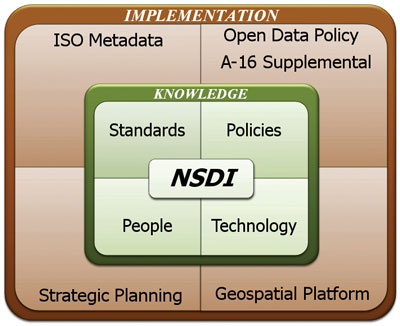
NSDI Implementation training.
FGDC Subcommittees and Working Group Reports
Cadastral Subcommittee
The Cadastral Subcommittee develops and implements plans to
coordinate cadastral data-related activities among Federal, State,
Tribal, and local governments and the private sector. In the Western
United States, the Subcommittee works with the wildland fire community
to identify sources of land parcel data, standardize available data,
and build sustainable operational procedures to provide land parcel
data in coordination with States. In other regions of the country, such
as the Midwest and the Southeast, the Subcommittee works with State
coordinators to identify county cadastral data contacts and to develop
authoritative sources of data with the States. The Subcommittee
coordinates with the Bureau of Land Management (BLM) to develop
sustainable datasets for rights and interests in land parcels that are
compliant with the national standards.
The Federal Lands Working Group was established in 2011 under the
Cadastral Subcommittee. The Working Group is an expansion of the
Federal Parcels Working Group that was formed in 2010. The long-term
goal of the Federal Lands Group is to develop a parcel-level national
cadastre of Federal lands that can be used to meet common Federal
agency needs.
Highlights for the Subcommittee include:
- BLM contributed the definitions and data standards for federally managed land to support individual agency efforts in developing rights and interests datasets conformant with the national standards. Significant progress has been achieved in establishing a Federal Surface Management Agency (SMA) dataset that is built from parcel-level information in agency datasets.
- The BLM established SMA definitions and core attribute requirements for parcel-level Federal surface-management datasets. The national SMA standardized Geographic Information System (GIS) dataset depicts Federal land for the United States and classifies this land by its active Federal SMA. A Federal SMA refers to a Federal agency with administrative jurisdiction over the surface of Federal lands. Participating agencies are expected to submit the necessary land status records to the appropriate BLM State Office for recordation into the Land Status Systems and to collaborate with BLM to reconcile discrepancies in the records.
- Worked with FGDC Cooperative Agreements Program award recipients and States and local agencies in the deployment and sustained delivery of standardized data. Presentations were made to the Appalachian Development Council, International Association of Assessing Officers (IAAO), and many State-based GIS, assessment, and homeland security meetings. Several papers were published in a variety of national and State journals.
- The Public Land Survey System (PLSS) Working Group completed the definition of Version 2 of the PLSS publication standard and is in the process of migrating PLSS datasets to this standard.
- The Federal Lands Working Group attained representation from the U.S. Forest Service, Bureau of Land Management, National Park Service, Fish and Wildlife Service, U.S. Census Bureau, U.S. Geological Survey, Bureau of Ocean Energy Management, Bureau of Indian Affairs, Bureau of Reclamation, and Department of Defense. The Working Group collaborated with BLM to produce and maintain their SMA standardized GIS and with the National Boundaries Group to heighten awareness of the national cadastre of Federal lands effort.
Geodetic Control Subcommittee
The Federal Geodetic Control Subcommittee exercises
governmentwide leadership in coordinating the planning and execution of
geodetic surveys, in developing standards and specifications for these
surveys, and in the exchange of geodetic survey data and technical
information.
Throughout 2013 the National Geodetic Survey (NGS) conducted a
comprehensive inventory and review of the agency’s existing geodetic
control standards, specifications, and guidelines documents. NGS then
determined updates needed for those existing documents and scheduled
the updates. These updated documents will be a critical part of how NGS
will prepare the Federal community and other users for the transition
to new geometric and geopotential datums.
In March 2013 the National Geodetic Survey’s GRAV-D (Gravity for the
Redefinition of the American Vertical Datum) project reached an
important milestone on time and within budget: 25 percent of airborne
gravity data has been acquired across the United States and its
territories. Those data will support the release of a new geopotential
(vertical) datum in approximately 2023 that will enable more accurate
determination of elevations. That increased accuracy will result in
improved inundation mapping, better monitoring of sea level, and more
accurate heights for the surveying community in support of the
construction of highways, bridges, and suburban development, among
other improvements.
In February 2013 the NGS staff presented talks at the Esri Federal
Users Conference in Washington, D.C., in a session titled "Geodesy and
National GIS." At the Esri International User Conference in San Diego,
California, in July 2013, the NGS led discussions on the fundamental
aspects of geodesy and positioning and the latest GIS developments,
with NGS staff providing training and information on NGS products and
services.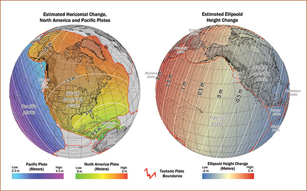
Estimated horizontal and ellipsoid height changes from
the North American Datum of 1983 to the new
geometric datum in 2023. Large-scale plate tectonic motion is mostly
horizontal, so horizontal changes
will be specific to the plates defined in the National Spatial
Reference System, as shown here for the
North America and Pacific plates. Ellipsoid height change will be
largely independent of tectonic plates.
Changes were computed using the National Geodetic Survey Horizontal
Time-Dependent
Positioning (HTDP) software.
Geologic Data Subcommittee
The Geologic Data Subcommittee coordinates Federal and non-Federal interests in geologic data, including the facilitation of exchange of information and transfer of data; the establishment and implementation of standards for quality, content, and transferability; and the coordination of the identification of requirements and the collection of spatial data to minimize duplication of effort where practicable and economical. The Subcommittee website is at ngmdb.usgs.gov/fgdc_gds/. On behalf of the Subcommittee, the USGS, the National Park Service, and the Association of American State Geologists (representing the State geological surveys) have continued to make progress on development and evaluation of a draft standard database design for dissemination of geologic maps. This design is named NCGMP09 to indicate its origin, under the auspices of the National Cooperative Geologic Mapping Program (NCGMP). In the past year, several agencies have published maps in this design, and acknowledgment of this design as a possible standard is gaining broader acceptance. Monthly teleconferences are now being held in order for the various agencies to share technical questions and to resolve issues related to whether the draft standard needs modification. Regarding the FGDC Digital Cartographic Standard for Geologic Map Symbolization, the Subcommittee continues to support it, through responses to technical questions regarding implementation, and by soliciting suggestions for updates to the standard.
Marine and Coastal Spatial Data Subcommittee
The Subcommittee represents a distributed network of
agencies and staff working to advance and implement the marine and
coastal elements of the National Spatial Data Infrastructure through
the development of coastal and marine data standards, enhanced access
to and utility of coastal and ocean framework data, and creation and
fostering of strategic partnerships. This past year, the
Subcommittee:
- Continued its leadership role for the Ocean Community on Data.gov through management of the community Web pages, adding appropriate content to the community, and providing technical support to the marine portal community.
- Complied with all requirements from the OMB Circular A–16 Supplemental Guidance including the identification of an Executive Champion for the Water – Oceans and Coasts Theme, refinement of National Geospatial Data Asset Datasets, and inclusion of appropriate content from the Water – Oceans and Coasts Theme in Data.gov and the national Geospatial Platform.
|
Success Story Marine Planning Portal Network Created to Support
Regional Marine Planning Challenge: A growing number of users rely on coastal and marine geospatial data to support research, planning, and decisionmaking processes. Accordingly, numerous atlases, portals, and catalogs have emerged to supply these users with such data. While each system has its own unique purpose and constituencies, the proliferation of systems creates a need and opportunity to leverage experience, expertise, and data across regions and between regional and national systems.
Action: A series of meetings were held with representatives from national, regional, and State data-management systems to build awareness of the current status of existing regional and national marine information systems, identify common data-management and exchange standards and procedures to be adopted by regional and national planning bodies and ocean governance groups, and identify methods to increase collaboration among marine data-management entities. These considerations led to the idea of creating a national network that would facilitate technical integration and collaboration across multiple systems.
Result: The Marine Planning Portal Network was formed in September 2012. With over 100 active members, the Network, through a combination of a listserv, webinar series, and informational resources, is intended to serve as one of the main conduits for communication between national, State, and regional portals, applications, and planning efforts. During fiscal year 2014, members will work to strengthen the existing Network by identifying topics of mutual interest and by discussing a shared vision for future data sharing and hosting.
|
||||
National Digital Orthoimagery Program (NDOP)
Subcommittee
The NDOP Subcommittee is responsible for developing a
national strategy for acquisition of orthoimagery data for Federal
agencies while creating and utilizing partnerships with State, Tribal,
local, and private organizations. The U.S. Department of Agriculture
(USDA) Farm Service Agency (FSA) National Agriculture Imagery Program
(NAIP) includes funding partnerships with the U.S. Department of the
Interior, the U.S. Forest Service (USFS), and the Natural Resources
Conservation Service (NRCS). NAIP is a 1-meter resolution, leaf-on,
digital, 4-band imagery program with an optional buy-up of ½-meter
resolution. Despite difficult financial circumstances, the funding
agencies identified 92 percent of the planned funding, allowing a total
of 23 States to be flown in 2013. The Urban Areas Program is a
high-resolution, leaf-off program funded by the National
Geospatial-Intelligence Agency (NGA) in partnership with the U.S.
Geological Survey (USGS). Partnerships frequently include Federal,
State, and local government agencies combining funding and efforts to
produce a product that meets multiple needs and saves costs.
Imagery data storage and distribution continue to be topics of concern
for NDOP agencies. The technical committee is investigating compression
techniques to reduce file sizes and storage costs while maintaining
image quality needed to meet mission requirements. The Geospatial
Platform and cloud technology are being considered as potential
solutions for delivery and storage. The USGS and the FSA established a
Memorandum of Understanding to improve the coordinated distribution of
NAIP data. FSA is also exploring techniques for rapid delivery, within
4 to 7 days of capture, of NAIP imagery to support emergency
operations. The NRCS and the National Oceanic and Atmospheric
Administration (NOAA) continue to collect imagery in hard-to-capture
areas such as the Pacific Islands, Hawaii, Puerto Rico, and Alaska. The
USGS is assuming responsibility for Landsat 8 operations following the
successful launch of the satellite on February 11, 2013. Working with
the Alaska Statewide Mapping Initiative, the Alaska Executive Committee
and its member agencies are pursuing a number of efforts to
cooperatively collect data over the State. The committee continues to
discuss how it may support A–16 Theme responsibilities. Of particular
interest is the ability to account for satellite datasets within the
Imagery Theme.
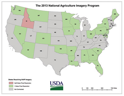
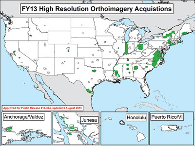
| Alaska Mapping Initiative Alaska is at the forefront of many nationally important issues including climate change, minerals and energy development, indigenous peoples’ heritage preservation, and natural resources management. Modern applications to address these critical issues require accurate, current data. Much of the existing statewide base map for Alaska was created around 1960 and at a lower resolution than the maps made over the conterminous United States. The U.S. Geological Survey National Geospatial Program is working with multiple Federal and State partners on a multi-year Alaska Mapping Initiative to help improve topographic maps and data statewide. Through the leadership of the Alaska Mapping Executive Committee, chaired by the Assistant Secretary for Water and Science of the Department of the Interior, and the Alaska Statewide Digital Mapping Initiative (SDMI), significant progress was made during the year toward the following joint goals:
|
Spatial Water Data Subcommittee
The Advisory Committee on Water Information (ACWI) and FGDC
created the Subcommittee on Spatial Water Data (SSWD) to assist
coordination of Federal and non-Federal interests in spatial water
data, including (1) facilitating the exchange of information and
transfer of data; (2) establishing and implementing standards for
quality, content, and transferability; and (3) coordinating the
identification of requirements and the collection of spatial data to
minimize duplication of effort where practicable and economical. This
past year, the Subcommittee:
- Changed leadership due to changes in staff assignments.
- Assisted FGDC in ensuring each National Geospatial Data Asset Dataset in the Waters—Inland Theme has metadata that are complete and accurate.
- Continued to focus on the national delivery of water quality and quantity results using standard geography and internationally adopted standards to harmonize the delivery of sampling points and time series data on flow, water levels, water quantity, and water quality.
- Began discussions among Subcommittee members on the appropriate integration of National Hydrography Dataset (NHD) and National Wetlands Inventory (NWI) data based on user needs.
Transportation Subcommittee
The Transportation Subcommittee works to coordinate and
support the NSDI and other transportation data-related activities among
stakeholders. The Subcommittee’s current areas of interest include all
modes of transportation, transportation networks, terminals, and
services (including intermodal freight and passenger), and the
movements of people and commodities using them. The fiscal year 2013
Subcommittee major achievements are listed below.
- Following the approval by the FGDC, the intermodal survey to develop an improved intermodal database was distributed by the Subcommittee. The results were gathered and survey recipient questions answered. The survey responses were compiled and summarized by the Subcommittee and presented to the FGDC in April 2013.
- To meet a 2013 goal identified by the Subcommittee and the Transportation for the Nation, leaders in the transit industry were contacted to discuss the possibility of transit being the next transportation component in the development of the Transportation for the Nation.
Vegetation Subcommittee
The mission of the Vegetation Subcommittee is the
coordination of terrestrial vegetative data-related activities among
Federal agencies and the establishment of mechanisms for the
coordinated development, use, sharing, and dissemination of terrestrial
vegetation data. In fiscal year 2013, the Subcommittee completed the
following activities:
- Developed a new Memorandum of Understanding to formalize the partnership between Federal and non-Federal partners working toward the vegetation goals.
- Finalized Phase II of the vegetation hierarchy revisions, which is a revision of the types and descriptions for the upper three levels of the U.S. National Vegetation Classification (USNVC) standard. Progress by the working group can be found at usnvc.org.
- Initiated a pilot project U.S. National Vegetation Process Testing Peer Review to identify new types and performance modifications to vegetation types currently described in the NVC standard. Results of the process will document the peer review process and the policy decisions necessary to standardize the evaluation of proposals for revising the dynamic content of the NVC. Peer reviews for the groups are completed. Also completed are the revised alliance concepts and the screening of the association descriptions (with funding from U.S. Forest Service agreements and U.S. Geological Survey contracts). The processes were developed by the Ecological Society of America (ESA) Vegetation Classification Panel.
- Continued to develop the cyber infrastructure to support the NVC and established a site to support the peer review process for finalizing the groups and for the alliance concept reviews. Also, continued to maintain a public archive for vegetation records in vegbank.org.
- Participated in an NSDI Cooperative Agreements Program project with the California Native Plant Society and the California Department of Fish and Game to establish an alliance and association-level classification for California using the NVC.
- Saw the adoption of the NVC standard by the Landscape Fire and Resource Management Planning Tools Project (LANDFIRE program), U.S. Forest Inventory and Analysis (FIA) program, Bureau of Land Management (BLM) guidance to field offices, National Park Service (NPS) Inventory and Monitoring Program, Natural Resources Conservation Service, and NPS and BLM for the Grand Canyon-Parashant National Monument and Lake Mead Natural Recreation Area.
- Hosted meetings, gave presentations, and manned a booth at that annual ESA Conference in August 2013.
- Held monthly teleconferences and developed educational materials that are available to the public.
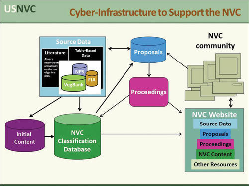
Flow chart showing how the cyber infrastructure will
manage the process and policy decisions
specific to reviewing proposed changes to the NVC in a dynamic process
of refining the NVC
content.
Wetlands Subcommittee
The Wetlands Subcommittee promotes standards of accuracy and
consistency in Federal geospatial wetlands data, exchanges information
on technological improvements for collecting spatial wetlands data,
encourages Federal and non-Federal communities to identify and adopt
standards and specifications for spatial wetlands data, and collects
and processes the requirements of Federal and non-Federal organizations
for spatial wetlands data. This year the Subcommittee:
- Continued outreach under the Implementation Plan for the Wetlands Mapping Standard through the support of the Association of State Wetlands Managers and the Wetlands Mapping Consortium via workshops, webinars, and information venues.
- Finalized the second edition of the Classification of Wetlands and Deepwater Habitats of the United States, which was endorsed by the FGDC.
- Worked with the Association of State Wetlands Managers to document the wide variety of uses of the wetlands layer of the NSDI.
- Completed the largest one-time increase in the amount of digitized legacy National Wetlands Inventory (NWI) data in the program’s history.
- Developed a Surface Waters and Wetlands Inventory that is an enhancement to the wetlands layer of the NSDI that includes the conversion of never-before served legacy NWI linear data with stream connections from various hydrologic datasets.
| Integrating the National Vegetation Classification
Standard A nationwide vegetation classification system is necessary to produce uniform statistics on vegetation resources across the Nation, facilitate information sharing between Federal agencies and other public and private organizations, and foster cooperation on vegetation management issues that transcend jurisdictional boundaries. The FGDC National Vegetation Classification (NVC) Standard was developed to serve this function; however, many existing classification systems for local vegetation types are still in use. For the NVC to be useful, local classification systems must be cross-walked with the NVC. With support from the NSDI Cooperative Agreements Program, California is one of the first States to perform a crosswalk at the alliance and group levels of the NVC hierarchy. The California Native Plant Society (CNPS) and the California Department of Fish and Game (CDFG) collaborated with NatureServe and the FGDC Vegetation Subcommittee to evaluate the NVC standard’s revised classification hierarchy in terms of California vegetation. They established links between the 480+ alliances in California to the mid and upper levels of the NVC hierarchy, including the new Groups and Macrogroups. NatureServe conducted an initial crosswalk between the NVC Standard (Version 2, FGDC-STD-005-2008) and the Manual of California Vegetation (cnps.org/cnps/vegetation/manual.php). Information was provided in the form of MS Access databases, Excel spreadsheets, and supporting documents, including Word documents of peer-reviewed NVC Group descriptions. This effort can serve as a model for others to use when they crosswalk vegetation classifications for regional databases. The relationships between the California classifications of alliances to the NVC hierarchy will be posted on websites so that users can access this information. For more information see www.fgdc.gov/grants/2012CAP/projects/G12AC20142.
|
Architecture and Technology Working Group
The Architecture and Technology Working Group (ATWG) works
to improve the understanding and integration of geospatial concepts by
mainstream governmental business planners and technical practitioners
through varied outreach mechanisms. The ATWG evaluates and develops the
technical architecture for the Geospatial Platform, identifies suitable
standards and applicability, sponsors training and outreach activities,
and supports testing of and enhancements to the Geospatial Platform. In
fiscal year 2013, the Working Group:
- Oversaw a third year of GeoCloud hosting and facilitation using the two developed reference platform software "stacks" for open-source and commercial geospatial solutions to expand shared services capability in the Geospatial Platform.
- Developed metadata recommendations for optimal indexing by Catalog.Data.gov and the Geospatial Platform.
- Provided an online publishers’ webinar for the Geospatial Platform and Catalog.Data.gov.
Metadata Working Group
The Metadata Working Group promotes awareness and best
practices among FGDC member agencies and other interested stakeholders
about the metadata component of geospatial data; facilitates the
coordination, development, use, sharing, and dissemination of
geospatial metadata; supports the implementation of geospatial metadata
and other related semantic and structural (that is, non-geospatial)
metadata standards established by Federal, national, and international
standards organizations such as the FGDC, Open Geospatial Consortium
(OGC), American National Standards Institute (ANSI), International
Organization for Standardization (ISO), Dublin Core Metadata Initiative
(DCMI), Open Source Metadata Framework (OMF), Ecological Metadata
Language (EML), and the World Wide Web Consortium (W3C).
In fiscal year 2013, Metadata Working Group (MWG) members provided
direct support to the FGDC Metadata Program and participated in the
Standards Working Group. Members contributed to quarterly
teleconferences, several agencies helped organize and actively
participated in the ISO Metadata Implementation Webinar, provided
constructive feedback in the development of the ISO Metadata Editor
Review critical features, and contributed comments to the NSDI
Strategic Plan. In July 2013, the MWG released an updated charter that
includes activities related to ISO metadata standards implementation,
the Geospatial Platform, National Geospatial Data Asset Themes, as well
as support for recently released national policies and guidance. The
MWG continues to serve as the primary conduit for the distribution of
information about geospatial metadata and other related semantic and
structural (non-geospatial) metadata standards, tools, training, and
implementation. Coordinating with the INCITS-L1 group, they provided
regular ISO geospatial metadata updates for the MWG.
Standards Working Group
The FGDC Standards Working Group is responsible for
promoting the development and implementation of standards in support of
the NSDI. For fiscal year 2013, the Working Group reported the
following accomplishments:
- Recommended FGDC endorsement of five geospatial standards, including four externally developed standards. For more information click here.
- Recommended public review of the National Shoreline Data Content Standard.
- Completed review of FGDC member agency participation in the FGDC Standards Working Group with FGDC Coordination Group members.
Users/Historical Data Working Group
The Users/Historical Data Working Group (UHDWG) promotes and
coordinates activities among Federal agencies who are primarily users
of, not generators of, geospatial data. The intent is to provide a
vehicle for those agencies that may not have a significant geospatial
infrastructure to collectively share their experiences and needs with
the larger geospatial community. In the past year, the UHDWG:
- Continued a program of outreach to prospective members. The listserv (sun8.loc.gov/listarch/uhdwg.html) for UHDWG members and those interested in its work has been active, not only in announcing meetings, but also as a conduit for discussion of topics such as the appraisal of digital assets and digital preservation.
- Held monthly Web and phone meetings for members to discuss issues and share presentations on related topics.
- Submitted a document titled "Guidance on the Selection and Appraisal of Geospatial Content of Enduring Value" to the FGDC Coordination Group for review and possible future use by Federal agencies and others.
Goals for Fiscal Year 2014
Geospatial Line of Business /Geospatial Platform
Initiative
- Coordinate with partners to provide and share National Geospatial Data Assets (NGDA) through the Geospatial Platform.
- Continue to provide the management oversight for the Office of Management and Budget (OMB) Circular A–16 Supplemental Guidance.
- FGDC endorsement of the implementation plan for OMB’s portfolio management guidance ("Implementation Plan"), with established milestones, to reduce duplication in the development and utilization of geospatial information.
Challenges: Obtaining continued participation from Federal partner agencies and finalizing the implementation plan for OMB’s portfolio management guidance.
OMB Circular A–16 Supplemental Guidance
- Finalize the initial list of NGDA Datasets and have agencies identify their Theme Champions and Dataset Stewards.
- Develop the A–16 Theme communities on the Geospatial Platform.
- Have agencies register all available NGDA Datasets with the Geospatial Platform.
- Complete a high-level baseline assessment of the maturity level of the Themes and initiate the baseline assessment of NGDA Datasets.
- Finalize annual Theme reporting requirements and maturity metrics for Themes and Datasets.
- Initiate Theme strategic plans and Dataset management plans.
- Finalize the A–16 Implementation Plan.
Challenges: Developing meaningful and consistent performance metrics for NGDA Themes and Datasets and ensuring adequate resources to implement the portfolio and its supporting tools.
Geospatial Cloud Initiative for the Geospatial
Platform
- Leveraging recent Federal Risk and Authorization Management Program (FedRAMP) certifications from other agencies and building on the new offerings of secure cloud services for the Department of the Interior (DOI), the Geospatial Platform will provide system and application certification for Geospatial Cloud (GeoCloud) shared services that are hosted through the DOI Foundation Cloud acquisition vehicle.
- Continue the work of the Geospatial Platform team with member agencies to clear certification of the ArcGIS Online environment for multiagency use as an underlying technology by the Geoplatform.gov portal.
- Plan key new GeoCloud offerings for fiscal year 2014, including the National Hydrography Dataset (NHD-Plus) and the Homeland Security Infrastructure Program (HSIP) Freedom data—both will provide data download and access to standard map services.
Challenges: Deployment of cloud services by Federal agencies has been hampered by the lack of system security accreditation through the new governmentwide approval FedRAMP process.
NSDI Strategic Plan
- Finalize the NSDI Strategic Plan through adoption by the FGDC Steering Committee.
- Seek endorsement of the NSDI Strategic Plan by the National Geospatial Advisory Committee.
- Designate officials, appointed from the FGDC Executive Committee, who will serve as the champion for each strategic goal in the plan. The champions will be responsible for overseeing team leaders and action teams, addressing each objective and its supporting actions. Each action team leader will develop a project plan, following adoption of the NSDI Strategic Plan, outlining how the goals and objectives will be achieved. The project plans will include tasks and milestones, responsible parties, performance measures, and resources required for each of the objectives.
- Continue to collaborate with the broader geospatial community in the implementation of the plan.
Challenges: A key challenge in implementing the goals in the NSDI Strategic Plan is the limited FGDC member agency staff and resources available to devote to the activities described in the plan. Successful implementation of the plan will also require extensive communication and collaboration with a broad range of partners and stakeholders.
National Geospatial Advisory Committee
- The National Geospatial Advisory Committee (NGAC) will provide ongoing review, feedback, and recommendations regarding the development and implementation of key issues and initiatives, including implementation of the NSDI Strategic Plan, the continued development of the Geospatial Platform, development of portfolio management approaches, geolocation privacy issues, and partnerships with other levels of government.
- The NGAC will hold three to four public meetings in fiscal year 2014.
- The FGDC will continue to manage the review, disposition, and implementation of NGAC recommendations, assess and respond to advice and recommendations from NGAC, and complete the next cycle of NGAC nominations and appointments in fiscal year 2014.
Challenges: The NGAC will face continuing challenges in developing effective advice and recommendations that reflect a consensus view across multiple sectors and perspectives on key issues such as the implementation of the NSDI Strategic Plan, geospatial portfolio management, and the Geospatial Platform, as well as emerging issues such as geolocation privacy.
Standards
- Continue to focus on implementation of core SDI standards, as identified in Chapter 10: Standards Suites for Spatial Data Infrastructure, www.gsdidocs.org/GSDIWiki/index.php/Chapter_10, of the SDI Cookbook that supports the Geospatial Platform.
- Build a repository of Geography Markup Language (GML)/eXtensible Markup Language schemata to promote uptake and implementation of geospatial standards.
- Continue participation in ISO, ANSI, and GWG geospatial standardization activities, as resources allow.
- Continue supporting activities within the OGC, including (1) sponsorship of Open Web Services-10 (OWS-10) Interoperability Testbed; (2) sponsorship of work with the Global Earth Observing System of Systems (GEOSS) Architecture Implementation Pilot (AIP); and (3) improvement of the information flow.
Challenges: Limited resources constrain the FGDC standards program; in particular, limited resources will prevent full participation in ISO, ANSI, GWG, and OGC geospatial standardization activities.
Geospatial Metadata
- Identify geospatial metadata education and outreach crosscuts with national initiatives such as the Geospatial Platform, the National Geospatial Data Asset (NGDA) Themes, and other emerging priorities.
- Establish a regular "Information Series" on ISO metadata implementation.
- Implement online metadata resources including new training materials, the FGDC Metadata Website redesign, and the ISO Metadata Editor Review.
Challenges: The greatest challenge that the FGDC Metadata Program faces is the ability to develop specific ISO metadata standard implementation guidance and support to ensure compliance with a series of recently released policies and directives. In addition, the technical expertise, software dependency, and geospatial metadata investment of NSDI stakeholders including NGDA Theme Leads varies greatly, resulting in the need to address an extremely wide range of implementation issues and needs.
International Activities
- The Group on Earth Observations/Global Earth Observation System of Systems (GEO/GEOSS) will continue to focus on simplifying access to quality Earth observation data and services. The FGDC will participate and continue to support the reorganized U.S. Group on Earth Observations (USGEO).
Challenges: Coordinating the variety of data access and distribution policies worldwide, and a need for expanded outreach to promote the use of GEOSS to find and access Earth observation data.
NSDI Training Program
- Increase the number and type of available NSDI training materials.
- Increase the number of NSDI training materials available online.
- Improve access to online training materials as part of the FGDC website redesign.
- Provide more Web-based live training.
Challenges: There are two metadata directives for geospatial data—Office of Management and Budget (OMB) Circular A–16 and the Open Data Policy. Guidance to agencies on how to fulfill both with a single implementation will be issued and training will need to be included as part of the solution.
FGDC Subcommittees and Working Groups
Cadastral Subcommitte
- Work with other Federal agencies to complete an initial dataset for the Surface Management Agency dataset that is built from parcel-level information in agency datasets; establish a data feature for Federal parcel information that can be integrated into the Cadastral National Spatial Data Infrastructure (CadNSDI) Publication guidelines.
- Coordinate with States and regional organizations to continue to promote the development and access to standardized parcel data that is based on authoritative data sources; the data should be easily accessible by data users. This activity includes the continued support for the national inventory of the status of parcel data development and access and the national inventory on State programs.
- The Public Land Survey System (PLSS) Working Group will continue to support the data quality improvement of the standardized PLSS datasets, complete as many Eastern States PLSS datasets as possible, and promote shared data stewardship for non-federally managed lands.
- The Federal Lands Working Group will develop prioritization rules to manage topology (boundary overlaps and gaps) while correcting authoritative data and, using one or two Western States with Federal parcel data, develop a prototype aggregated Federal boundary geodatabase.
Geodetic Control Subcommittee
- Continue education, outreach, development of transition tools and applications, and capacity building activities to prepare users for the transition to new geometric and geopotential datums.
- Update existing guidelines, standards, and specifications to support the transition to new datums.
- Engage with international standards activities via the InterNational Committee on Information Technology Standards Technical Committee L1 (INCITS L1) and the ISO Technical Committee 211.
Challenges: Support activities related to OMB Circular A–16 Supplemental Guidance and the Geospatial Platform.
Geologic Data Subcommittee
- Promote among geologic map-producing agencies an improved technical understanding of the draft standard geologic map database design, named NCGMP09. Continue to hold monthly teleconferences among those agencies in order to raise, address, and resolve any technical or procedural issues related to its evaluation and implementation.
- Using comments and suggestions from users, consider revising the FGDC Digital Cartographic Standard for Geologic Map Symbolization that was released in 2006.
Challenges: Progress toward establishing NCGMP09 as a Federal standard; efforts to revise the FGDC Digital Cartographic Standard for Geologic Map Symbolization depends on sufficient availability of personnel and other resources. This is a particular challenge as agency budgets and staffing become increasingly restricted.
Marine and Coastal Spatial Data Subcommittee
- Continue to support and align the efforts of Data.gov, Ocean.Data.gov, Geoplatform.gov, and the A–16 Supplemental Guidance related to the Marine and Coastal Theme.
National Digital Orthoimagery Program (NDOP)
Subcommittee
- Establish a new 3-year multiagency agreement (2015–2017) for cooperative funding of the National Agriculture Imagery Program (NAIP).
- Establish a Memorandum of Understanding between the Farm Service Agency and the U.S. Geological Survey for coordinated distribution of NAIP.
- Update the NGDA Dataset list for the Imagery Theme.
Challenges: Investigate the use of the Geospatial Platform "marketplace" capabilities for tracking and displaying Federal agency data-acquisition projects.
Spatial Water Data Subcommittee
- Continue to monitor the operations and maintenance activities associated with the core data layers that include the National Hydrography Dataset (NHD), the Watershed Boundary Dataset (WBD), and key derivatives of the National Elevation Dataset (NED).
- Continue coordination and technical exchanges related to the National Wetlands Inventory (NWI) and NHD.
- Provide input from participating agencies for the USGS Water Data Business Requirements Study.
- Continue efforts to review and inventory participating agencies’ surface-water monitoring and gaging datasets.
Transportation Subcommittee
- Identify a baseline of transportation datasets (non-road) that would complete Transportation for the Nation and would be adopted into the Transportation Theme as part of the NGDA Datasets.
- Assist in the development of the Transportation for the Nation plan documents and support the OMB A–16 Supplemental Guidance implementation plan.
Vegetation Subcommittee
- Further the avenues and resources for full U.S. National Vegetation Classification (USNVC) implementation.
- Provide access to the full hierarchy through usnvc.org.
- Submit revised and codified classification of California and adjacent Western States that will be the result of a NSDI Cooperative Agreements Program project.
- Continue outreach to potential users of the USNVC.
- Conduct a workshop/field trip in conjunction with the Ecological Society of America (ESA) education subcommittee and have a face-to-face meeting of this subcommittee.
Wetlands Subcommittee
- Implement the second edition of "Classification of Wetlands and Deepwater Habitats" by assuring updating of the Wetlands Mapping Standard, training, online tools, and other website references.
- Further the discussion, through the Subcommittee and the Association of State Wetland Managers and other stakeholder groups, of how the wetlands layer of the NGDA can be completed and updated by stakeholders to implement the recent National Wetlands Mapping Standard.
- Launch the coordination of the new Inland – Water Theme; co-leads are the Fish and Wildlife Service (FWS) and U.S. Geological Survey, with the involvement of stakeholders.
Challenges: Although the FWS National Wetlands Inventory will continue to provide stakeholders with wetland data standards, quality, integrity, integration, maintenance, and distribution, the Subcommittee is challenged with encouraging stakeholders such as Federal, State, Tribal, and territorial agencies to assume wetland mapping responsibility for their areas of interest as the FWS shifts priorities away from producing new data and updated data to completing a wetlands layer of NSDI by digitizing legacy data. In addition, the Subcommittee is challenged with identifying additional avenues of support for the Wetlands Subcommittee and the Inland – Waters Theme as the FWS shifts its priorities and redirects National Wetlands Inventory staff.
The Architecture and Technology Working Group
- Convene technical outreach sessions for the Geospatial Platform.
- Finalize Assessment and Authorization (A&A) for shared geospatial services and portals for the Geospatial Platform.
Metadata Working Group
- Facilitate awareness about geospatial metadata standards, their application, and implementation, including those relevant to the NGDA Themes and the Geospatial Platform initiative.
- Advance the ISO geospatial metadata transition and identify implementation best practices.
Standards Working Group
- Working Group members will continue their participation in external geospatial standards bodies to identify and recommend standards for FGDC endorsement.
- The Working Group will continue to recommend standards for advancement through the FGDC standards process.
Users/Historical Data Working Group
- Continue Working Group outreach to all interested parties, both inside and outside the Federal Government.
- Continue to provide input on the Geospatial Platform.
- Remain active in the development and maintenance of the database, listing data steward contacts across the Federal Government.
- Continue work on the Selections and Appraisal of Records Guidance document.
- Continue to provide coordinated input to the Library of Congress Geospatial Data Preservation Resource Center.
- Explore ways to provide input to Data.gov on enhancing access to historic geospatial datasets.
- Report on and liaison with the International Council for Science’s Committee on Data for Science and Technology (ICSU CODATA) Task Group on data at risk.


